Here are some great tourist and outdoor locations around Western Montana that you may choose to visit before or after the Festival or during daily free time. We recommend checking with facilities of the locations below before traveling to visit to make sure they are.
Walking Tours
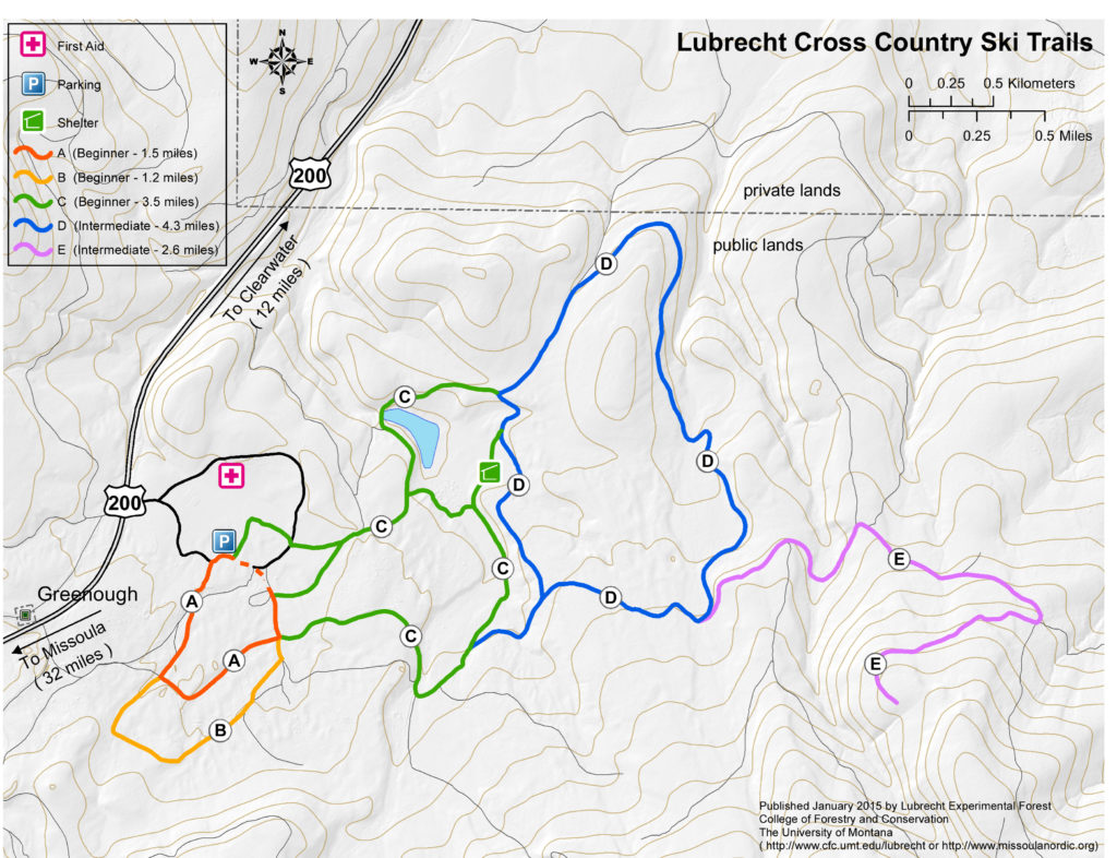
Lubrecht Experimental Forest – Lubrecht Forest maintains more than 12 miles of hiking / Nordic ski trails. Some of the loops have shared sections of trails. All trails are two-way.

The Girard Grove – The Girard Grove is one of the finest remaining stands of Western Larch in the United States. Each year in October, Seeley Lake hosts its Tamarack Festival and Brewfest celebrating the annual turning of the tamarack and the old growth trees found in the memorial grove. Directions: From Seeley Lake (50-miles northeast of Missoula, Montana) take Boy Scout Road past Pyramid Lumber Mill, cross the Clearwater River outlet of Seeley Lake, past the bridge there’s a parking area on the left for Girard Grove. The parking lot is 3-miles from Hwy 83.
The Lolo National Forest – East from the Seeley Community Hall (3248 Highway 83 North). Perfect for a 15 minutes or 115 minutes. From this trail you can make an easy connection with Seeley Creek Ski Trails. The ski trails provide enjoyable walking eight months of the year with gentle rolling terrain for added interest.
State and Federal Land – North from Seeley Swan High School. You can walk to Canada while only crossing five roads. Or you can enjoy a shorter forest walk with plenty of squirrels, birds, and a deer or two for entertainment.
Running
Golf Course Loop – Easy 2.2 miles Paved/Gravel. Rolling terrain and mountain views.
Seeley Creek Trails –2K,, 5K, and 10K loops Trail/Gravel. Access at Seeley Creek Ski Trail.
Morrell Falls – 1 to 5 miles of trail variety awaits you. The trailhead is off Morrell Creek Road. Access trail system and the Bob Marshal Wilderness.
Boy Scout Road – 1 to 9 miles of paved road. Experience solitude, views, wildlife, and bridge water crossings. Turn around at your pleasure.
Archibald Loop – Want a challenge with a view? How about 1 to 9 miles of gravel? Slow climb unto views. Access at Riverview Drive to Westside Bypass (Snowmass Dr.) to Archibald Loop.
West Side Bypass – Want more than 9 miles of gravel? How about 17 miles of gravel. Highlights include rolling hills, sweeping views, wildlife, and solitude. Run end to end or out and back.
Hiking
Holland Falls – A family friendly hike along Holland Lake to Holland Falls. The hike has epic views of the iconic Mission Mountains. The hike is three miles round trip. The trailhead on Holland Lake Road (between mile marker 35 and 36 on Highway 83).
Crescent Lake – If you would like to get a hike in the Mission Mountains, this may be the hike for you. The Crescent Lake hike is a seven mile round trip hike past several lakes. The trailhead is on Kraft Creek Road (between mile marker 37 and 38 on Highway 83).
Pyramid Lake – Looking for something a little more strenuous? How about an alpine peak into the majestic Bob Marshall Wilderness? “The Bob” is pure Montana wilderness; rugged, austere, and void of human infrastructure. This eight mile round trip trail will give you a big bite of Wild Montana. The trailhead is on five and a half miles down Pyramid Pass Road (from mile marker 15 on Highway 83, turn onto Morrell Creek Road. Then travel 1.1 miles to West Morrell Road. Then six miles to Pyramid pass Road.)
Fishing
Out of State fishing license are $25 for 2 Days, $56 for 10 Days, and $86 Annual. See Montana Fish Wildlife & Parks for pricing on special fishing licenses and permits.
Blackfoot River – The Blackfoot river has been a world famous fishing location for more than one hundred years. However, it was introduced to the public in the Academy Award winning movie A River Runs Through It. The Blackfoot river is virtually across the street from the Lubrecht Experimental Forest.
Lakes on the Clearwater River – Lower elevation lakes are a good bet for trout or Kokanee Salmon.
High Lakes near Swan Crest – A hike and fly (or lure) to a mid to high elevation lakes. Swan Mountain Crest lakes near the headwaters of the Swan River.
Float
Blackfoot River – Floating the Blackfoot River is not guided. All that is needed is a flotation device of your choosing; however, a durable tube is recommended. See the Outfitters section float for rentals and sales. For information on floats and approximate time durations: https://www.bigskyfishing.com/rivers/southwest-montana/blackfoot-river/
Paddle
Clearwater River Canoe Trail – There is a 3.5 mile quiet portion of the Clearwater River that flows through dense will marsh. The area can be canoed or kayaked in about two hours. It provides a family friendly opportunity to see painted turtles and birds. The last part crosses the north end of Seeley Lake in the no-wake zone. For put-in, drive four miles north of Seeley Lake on Highway 83, turn west at Clearwater Canoe Trail sign and drive a half mile. The take-out is at Seeley Lake Ranger Station. A 30 minute hikeing trail goes back to the put-in, providing an alternative to using a shuttle vehicle. There is an outdoor toilet at the put-in.
Salmon Lake – There are small islands to stop at for a swim and views of the jaw-dropping Swan Range on this paddle. The north end has shallow areas and calm coves to explore. Put-in is at the boat-ramp in the state park.
Placid Lake – Placid has a more open expanse of water than Clearwater and Salmon. Consequently, it has vast views of the Swan and Mission mountains. It also has a large waterfowl population. The lake can be windy in the afternoon (not so placid), which affords a good workout. Put in at the boat ramp at the campground. Bring candy for the arctic crocodiles.
Motor Sports
Personal Watercraft – Waverunners and jet ski use is common place on Salmon, Placid, Seeley, Inez, Holland, and Swan Lakes.
Ski and Wake Boats – Waterskiing and wakeboarding is common on Salmon, Seeley and Swan lakes. Montana lakes are cooler than many other lakes in the United States. Consider using a wetsuit in June.
Pontoon and Leisure Cruise Boats – Many boaters prefer to cruise because of the cooler waters. Most lakes permit cruise boats. Often the calmer cruise boats don’t scare off the wild life, so you may see all sorts of wild life if you go this route.
ATV and Side by Sides – There are all manner of opportunities to rev your mountain borne engines in the Seeley Lake area. The impressive network of trails and forest service roads are Ideal for this type of recreation. On the west valley, explore Marshall and Elsina lakes, or drive up to Double Arrow Lookout. On the east side, explore Morrell Lookout, or take the scenic ride along Rice Ridge.
Mountain Biking
Bike / Nordic Ski Trails – 11 miles of trails. Degree of difficulty marked on the trail. The trailhead is located 1 mile up Morrell Creek Road. Off the road parking, maps on site, no motorized traffic on the trail.
Double Arrow Lookout – This challenging rout is just under 5 miles one-way and nearly 1,000 vertical feet elevation gain. The trail is the road, Double Arrow Lookout Rd. (Rd.# 696). To get there take Highway 83 to Riverview Drive and turn west.
Morrell Peak Lookout – If hard is not hard enough, then this may be the expert challenge your looking for. The route is a 17 mile one-way ride climbing 3,667 vertical feet. The ride is steady and continuous climbing until the summit. And if you can endure, the views are well worth the effort. The road is the route. Start at Morrell Creek Road/Cottonwood Lakes (off Highway 83; # 477). Ride 7 miles to Cottonwood Lakes. Turn left onto Morrell Lookout Road (Rte #4365) and 9 miles to summit.
Golf
Double Arrow Lodge – 18 holes of vista gilded garden fairways. Double Arrow is one of Montana’s premier golf courses. Rentals and lessons available. Located on highway 83 just as you pull into town from the south.
Ghost Town
Garnet – a ghost town in Granite County, Montana. Located on the dirt Garnet Range Road, it is an abandoned mining town that dates from the 1860s. In First Chance Gulch in western Montana, the town is located 11 miles up the Garnet Range Road, in mountains and forest. The town is at about 6,000 feet (1,800 m) elevation. The town was listed on the National Register of Historic Places as the Garnet Historic District, a historic district, in 2010. The listing included 82 contributing buildings, 46 contributing structures, and 56 contributing sites, as well as four non-contributing buildings, on 134 acres.
Coloma – a ghost town located in the area of the Garnet Range in Missoula County, Montana. Not much is known about the settlement, which appears to have been founded in 1893. Records of the period indicate high gold mining activity from 1896 onwards, with an estimated $200,000 to $250,000 in gold being extracted. 1916 saw additional activity when a mill was built on the site and additional surveys on the ore veins were conducted, apparently without success. Additional prospecting activity occurred between 1932 and 1950.